
Myrtle Grove topographic map
Click on the map to display elevation.
About this map
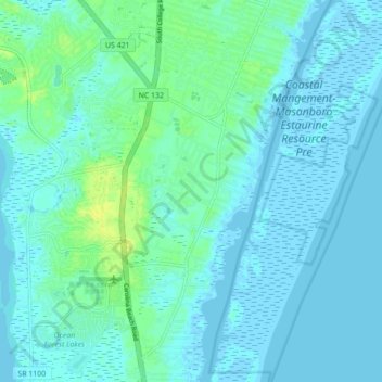
Name: Myrtle Grove topographic map, elevation, terrain.
Average elevation: 13 ft
Minimum elevation: -10 ft
Maximum elevation: 49 ft
New Hanover County trails, hiking, mountain biking, running and outdoor activities
Other topographic maps
Click on a map to view its topography, its elevation and its terrain.
Lincoln Forest
United States > North Carolina > New Hanover County > Wilmington
Average elevation: 43 ft
Carolina Beach
United States > North Carolina > New Hanover County > Carolina Beach
Average elevation: 3 ft
Princess Place
United States > North Carolina > New Hanover County > Wilmington
Average elevation: 30 ft
College Acres
United States > North Carolina > New Hanover County > Wilmington
Average elevation: 36 ft