Geolocate

Starlight topographic map

Click on the map to display elevation.

About this map

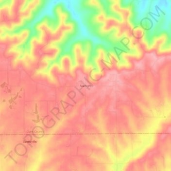
Name: Starlight topographic map, elevation, terrain.

Location: Starlight, Clark County, Indiana, 47106, United States (38.39506 -85.91247 38.43506 -85.87247)

Average elevation: 837 ft

Minimum elevation: 551 ft

Maximum elevation: 965 ft

Clark County trails, hiking, mountain biking, running and outdoor activities

Other topographic maps

Click on a map to view its topography, its elevation and its terrain.

Oak Park

United States > Indiana > Clark County

Average elevation: 459 ft

New Washington

United States > Indiana > Clark County

Average elevation: 702 ft

Utica

United States > Indiana > Clark County

Average elevation: 466 ft

Memphis

United States > Indiana > Clark County

Average elevation: 502 ft

Gear up for your next adventure:

🥩Freeze-Dried Meals - Nutritious and lightweight food for remote expeditions
💧Water Filtration Bottles - Safely drink from streams and lakes while exploring
🪶Trail Camera - Capture wildlife on your hikes
🧦Hiking Socks - Comfortable socks to prevent blisters on long hikes
👓Polarized Sunglasses - Outdoor sunglasses for glare reduction

As an Amazon Associate, this site earns from qualifying purchases at no extra cost to you.