
Make a donation
Gear up for your next adventure:
As an Amazon Associate, this site earns from qualifying purchases at no extra cost to you.
Torre do Pinhão topographic map
Click on the map to display elevation.
Make a donation
Gear up for your next adventure:
As an Amazon Associate, this site earns from qualifying purchases at no extra cost to you.
About this map
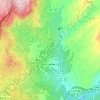
Name: Torre do Pinhão topographic map, elevation, terrain.
Location: Torre do Pinhão, Sabrosa, Vila Real, Portugal (41.35314 -7.65094 41.41255 -7.59513)
Average elevation: 2,513 ft
Minimum elevation: 1,837 ft
Maximum elevation: 3,652 ft
Make a donation
Gear up for your next adventure:
As an Amazon Associate, this site earns from qualifying purchases at no extra cost to you.
Other topographic maps
Click on a map to view its topography, its elevation and its terrain.
Vale das Gatas
Portugal > Vila Real > Sabrosa > São Lourenço de Ribapinhão
Average elevation: 1,965 ft
Make a donation
Gear up for your next adventure:
As an Amazon Associate, this site earns from qualifying purchases at no extra cost to you.
Make a donation
Gear up for your next adventure:
As an Amazon Associate, this site earns from qualifying purchases at no extra cost to you.