Geolocate

Lejunior topographic map

Click on the map to display elevation.

About this map

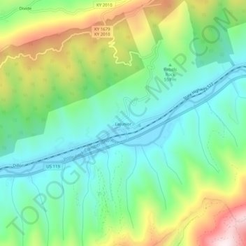
Name: Lejunior topographic map, elevation, terrain.

Location: Lejunior, Harlan County, Kentucky, 40865, United States (36.89721 -83.21278 36.93721 -83.17278)

Average elevation: 1,919 ft

Minimum elevation: 1,243 ft

Maximum elevation: 3,301 ft

Harlan County trails, hiking, mountain biking, running and outdoor activities

Other topographic maps

Click on a map to view its topography, its elevation and its terrain.

Pine Mountain

United States > Kentucky > Harlan County

Average elevation: 1,759 ft

Gear up for your next adventure:

🩹Survival Bandages - High‑quality bandages for emergencies
🪶Multi‑Purpose Knife - Useful blade for camp and trail
🌄Hiking Binoculars - Compact binoculars for scenic views and trail spotting
🚗GPS Dash Cams - Record your scenic drives through mountain passes and canyons
🛰️Satellite Messengers - Emergency SOS and two-way messaging for off-grid adventures

As an Amazon Associate, this site earns from qualifying purchases at no extra cost to you.