
Femundsee topographic map
Interactive map
Click on the map to display elevation.
About this map
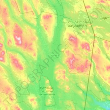
Name: Femundsee topographic map, elevation, terrain.
Location: Femundsee, Innlandet, Norwegen (61.91853 11.70992 62.43409 11.98666)
Average elevation: 2,697 ft
Minimum elevation: 1,778 ft
Maximum elevation: 5,217 ft
Other topographic maps
Click on a map to view its topography, its elevation and its terrain.
Søndre Land
Søndre Land, Innlandet, Norwegen, Trollstigen
Average elevation: 1,506 ft
Trysilfjellet
Trysilfjellet, Trysil, Innlandet, Norwegen
Average elevation: 2,989 ft
Brumunddal
Brumunddal, Ringsaker, Innlandet, 2382, Norwegen
Average elevation: 850 ft
Skeikampen
Skeikampen, Gausdal, Innlandet, 2652, Norwegen
Average elevation: 3,012 ft
Skandinavisches Gebirge
Skandinavisches Gebirge, Lom, Innlandet, Norwegen
Average elevation: 6,726 ft