
Gjende topographic map
Interactive map
Click on the map to display elevation.
About this map
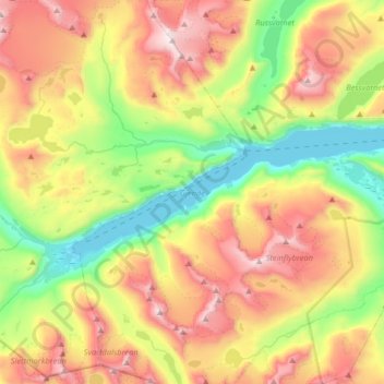
Name: Gjende topographic map, elevation, terrain.
Location: Gjende, Vågå, Innlandet, Norwegen (61.44601 8.48410 61.49954 8.80836)
Average elevation: 5,164 ft
Minimum elevation: 3,228 ft
Maximum elevation: 7,759 ft
Other topographic maps
Click on a map to view its topography, its elevation and its terrain.
Søndre Land
Søndre Land, Innlandet, Norwegen, Trollstigen
Average elevation: 1,506 ft
Trysilfjellet
Trysilfjellet, Trysil, Innlandet, Norwegen
Average elevation: 2,989 ft
Brumunddal
Brumunddal, Ringsaker, Innlandet, 2382, Norwegen
Average elevation: 850 ft
Skeikampen
Skeikampen, Gausdal, Innlandet, 2652, Norwegen
Average elevation: 3,012 ft
Skandinavisches Gebirge
Skandinavisches Gebirge, Lom, Innlandet, Norwegen
Average elevation: 6,726 ft