Geolocate

Baranzate topographic map

Click on the map to display elevation.

About this map

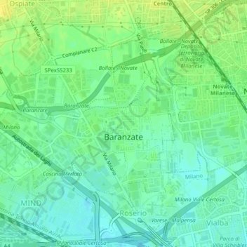
Name: Baranzate topographic map, elevation, terrain.

Location: Baranzate, Milan, Lombardy, 20021, Italy (45.51900 9.09673 45.53722 9.12494)

Average elevation: 482 ft

Minimum elevation: 453 ft

Maximum elevation: 522 ft

Other topographic maps

Click on a map to view its topography, its elevation and its terrain.

Milan

Italy > Lombardy > Milan > Milan

Average elevation: 427 ft

Tregarezzo

Italy > Lombardy > Milan > Segrate > San Felice

Average elevation: 377 ft

Cascina Confaloniera

Italy > Lombardy > Milan > Rosate

Average elevation: 351 ft

Vaiano Valle

Italy > Lombardy > Milan > Milan

Average elevation: 361 ft

Gear up for your next adventure:

🎒Trekking Poles - Sturdy poles for balance and stability on rough terrain
🥇GPS Hiking Watch - Multi‑sport GPS watch with navigation and trail tracking
🪄Magnetic Compass - Accurate compass for navigation
🔌Solar Panel Charger - Charge gear sustainably outdoors
Backpacking Tents - Weight-optimized shelters for multi-day topographic surveys

As an Amazon Associate, this site earns from qualifying purchases at no extra cost to you.