Geolocate

Mekinock topographic map

Interactive map

Click on the map to display elevation.

About this map

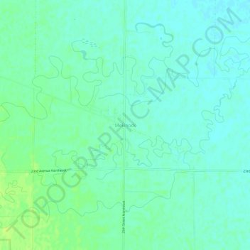
Name: Mekinock topographic map, elevation, terrain.

Location: Mekinock, Grand Forks County, North Dakota, 58258, United States (47.99277 -97.38342 48.03277 -97.34342)

Average elevation: 860 ft

Minimum elevation: 843 ft

Maximum elevation: 886 ft

Mekinock is an unincorporated community in eastern Grand Forks County, North Dakota, United States. It lies northwest of the city of Grand Forks, the county seat of Grand Forks County. Mekinock's elevation is 860 feet (262 m). It has a post office with the ZIP code 58258.

Wikipedia (CC-BY-SA 3.0)

Other topographic maps

Click on a map to view its topography, its elevation and its terrain.

Arvilla

United States > North Dakota > Grand Forks County

Arvilla, Grand Forks County, North Dakota, 58214, United States

Average elevation: 1,010 ft

Inkster

United States > North Dakota > Grand Forks County

Inkster, Grand Forks County, North Dakota, United States

Average elevation: 1,024 ft

Manvel

United States > North Dakota > Grand Forks County

Manvel, Grand Forks County, North Dakota, United States

Average elevation: 817 ft

Johnstown

United States > North Dakota > Grand Forks County

Johnstown, Grand Forks County, North Dakota, United States

Average elevation: 873 ft

Northwood

United States > North Dakota > Grand Forks County

Northwood, Grand Forks County, North Dakota, United States

Average elevation: 1,119 ft

Emerado

United States > North Dakota > Grand Forks County

Emerado, Grand Forks County, North Dakota, 58228, United States

Average elevation: 899 ft

Thompson

United States > North Dakota > Grand Forks County

Thompson, Grand Forks County, North Dakota, United States

Average elevation: 866 ft

Reynolds

United States > North Dakota > Grand Forks County

Reynolds, Grand Forks County, North Dakota, United States

Average elevation: 915 ft

Gilby

United States > North Dakota > Grand Forks County

Gilby, Grand Forks County, North Dakota, 58235, United States

Average elevation: 879 ft

Hannah Junction

United States > North Dakota > Grand Forks County

Hannah Junction, Grand Forks County, North Dakota, United States

Average elevation: 1,129 ft

Larimore

United States > North Dakota > Grand Forks County

Larimore, Grand Forks County, North Dakota, United States

Average elevation: 1,125 ft

Grand Forks

United States > North Dakota > Grand Forks County

Grand Forks, Grand Forks County, North Dakota, United States

Average elevation: 837 ft

Turtle River

United States > North Dakota > Grand Forks County

Turtle River, Grand Forks County, North Dakota, 58214, United States

Average elevation: 997 ft

Grand Forks

United States > North Dakota > Grand Forks County > Grand Forks

Grand Forks, Grand Forks County, North Dakota, 58201, United States

Average elevation: 846 ft

Niagara

United States > North Dakota > Grand Forks County

Niagara, Grand Forks County, North Dakota, 58266, United States

Average elevation: 1,434 ft