
Make a donation
Gear up for your next adventure:
As an Amazon Associate, this site earns from qualifying purchases at no extra cost to you.
Turtle River topographic map
Click on the map to display elevation.
Make a donation
Gear up for your next adventure:
As an Amazon Associate, this site earns from qualifying purchases at no extra cost to you.
About this map
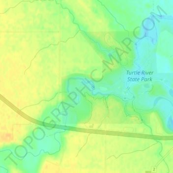
Name: Turtle River topographic map, elevation, terrain.
Average elevation: 997 ft
Minimum elevation: 948 ft
Maximum elevation: 1,033 ft
Grand Forks County trails, hiking, mountain biking, running and outdoor activities
Make a donation
Gear up for your next adventure:
As an Amazon Associate, this site earns from qualifying purchases at no extra cost to you.
Other topographic maps
Click on a map to view its topography, its elevation and its terrain.
Grand Forks
United States > North Dakota > Grand Forks County > Grand Forks
Grand Forks is 74 miles (119 km) north of the Fargo-Moorhead area and 145 miles (233 km) south of Winnipeg, Manitoba. Grand Forks is on the western bank of the Red River of the North in an area known as the Red River Valley. The term "forks" refers to the forking of the Red River with the Red Lake River near…
Average elevation: 846 ft
Make a donation
Gear up for your next adventure:
As an Amazon Associate, this site earns from qualifying purchases at no extra cost to you.
Make a donation
Gear up for your next adventure:
As an Amazon Associate, this site earns from qualifying purchases at no extra cost to you.
Arvilla
United States > North Dakota > Grand Forks County
Arvilla (also Orange) is an unincorporated community in central Grand Forks County, North Dakota, United States. It lies along U.S. Route 2, west of the city of Grand Forks, the county seat of Grand Forks County. Its elevation is 1,004 feet (306 m). The community was first named Orange for Orange County, New…
Average elevation: 1,010 ft
Make a donation
Gear up for your next adventure:
As an Amazon Associate, this site earns from qualifying purchases at no extra cost to you.
Mekinock
United States > North Dakota > Grand Forks County
Mekinock is an unincorporated community in eastern Grand Forks County, North Dakota, United States. It lies northwest of the city of Grand Forks, the county seat of Grand Forks County. Mekinock's elevation is 860 feet (262 m). It has a post office with the ZIP code 58258.
Average elevation: 860 ft