Geolocate

Loretto topographic map

Click on the map to display elevation.

About this map

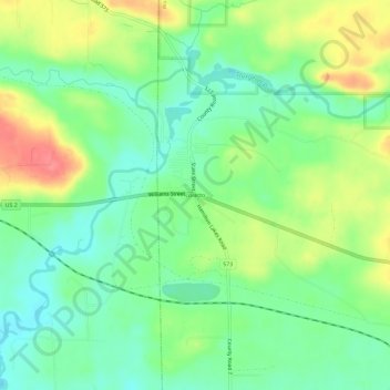
Name: Loretto topographic map, elevation, terrain.

Location: Loretto, Waucedah Township, Dickinson County, Michigan, 49852, United States (45.75718 -87.83513 45.79718 -87.79513)

Average elevation: 915 ft

Minimum elevation: 823 ft

Maximum elevation: 1,060 ft

Dickinson County trails, hiking, mountain biking, running and outdoor activities

Other topographic maps

Click on a map to view its topography, its elevation and its terrain.

Quinnesec

United States > Michigan > Dickinson County

Average elevation: 1,047 ft

Norway

United States > Michigan > Dickinson County

Average elevation: 1,020 ft

Kingsford

United States > Michigan > Dickinson County

Average elevation: 1,148 ft

Gear up for your next adventure:

🪶LED Camping Lantern - Bright lantern for camp lighting
🛡️Bear Spray Outdoor - Protection in bear country hikes
🧢Sun Protection Hats - Wide-brimmed and UPF-rated hats for high-altitude sun safety
📡Handheld GPS Device - Reliable handheld GPS for outdoor navigation
🪑Portable Camp Table - Compact table for campsite meals

As an Amazon Associate, this site earns from qualifying purchases at no extra cost to you.