Geolocate

Langston topographic map

Interactive map

Click on the map to display elevation.

About this map

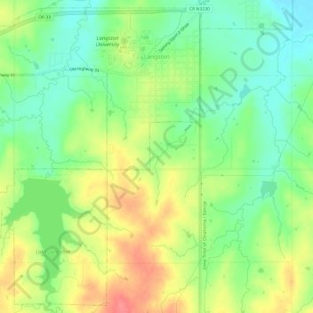
Name: Langston topographic map, elevation, terrain.

Location: Langston, Logan County, Oklahoma, United States (35.90642 -97.30669 35.95257 -97.24682)

Average elevation: 968 ft

Minimum elevation: 869 ft

Maximum elevation: 1,096 ft

Other topographic maps

Click on a map to view its topography, its elevation and its terrain.

Meridian

United States > Oklahoma > Logan County

Meridian, Logan County, Oklahoma, United States

Average elevation: 1,017 ft

Guthrie

United States > Oklahoma > Logan County

Guthrie, Logan County, Oklahoma, 73044, United States

Average elevation: 1,083 ft

Iconium

United States > Oklahoma > Logan County

Iconium, Logan County, Oklahoma, United States

Average elevation: 1,073 ft

Coyle

United States > Oklahoma > Logan County

Coyle, Logan County, Oklahoma, United States

Average elevation: 896 ft

Crescent Springs

United States > Oklahoma > Logan County

Crescent Springs, Logan County, Oklahoma, 73028, United States

Average elevation: 1,007 ft