Geolocate

Butler topographic map

Click on the map to display elevation.

About this map

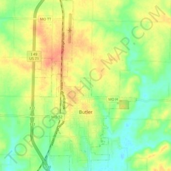
Name: Butler topographic map, elevation, terrain.

Location: Butler, Bates County, Missouri, 64730, United States (38.23677 -94.35911 38.30022 -94.30897)

Average elevation: 840 ft

Minimum elevation: 768 ft

Maximum elevation: 915 ft

Bates County trails, hiking, mountain biking, running and outdoor activities

Other topographic maps

Click on a map to view its topography, its elevation and its terrain.

Johnstown

United States > Missouri > Bates County

Average elevation: 823 ft

Hudson

United States > Missouri > Bates County

Average elevation: 873 ft

Gear up for your next adventure:

🎒Gear Packing Cubes - Organize your backpack efficiently
🪶Survival Guide Book - Expert advice for emergency preparedness
🛏️Cold Weather Sleeping Bag - Warm sleeping bag for cold conditions
🌐World Map Poster - Decorative world maps with topographic info
🗺️NatGeo Topo Maps - High-quality waterproof printed topographic maps of US Parks

As an Amazon Associate, this site earns from qualifying purchases at no extra cost to you.