
Make a donation
Gear up for your next adventure:
As an Amazon Associate, this site earns from qualifying purchases at no extra cost to you.
Orangeville topographic map
Click on the map to display elevation.
Make a donation
Gear up for your next adventure:
As an Amazon Associate, this site earns from qualifying purchases at no extra cost to you.
About this map
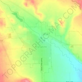
Name: Orangeville topographic map, elevation, terrain.
Location: Orangeville, Emery County, Utah, 84537, United States (39.21316 -111.07675 39.24573 -111.04318)
Average elevation: 5,827 ft
Minimum elevation: 5,676 ft
Maximum elevation: 5,984 ft
Emery County trails, hiking, mountain biking, running and outdoor activities
Make a donation
Gear up for your next adventure:
As an Amazon Associate, this site earns from qualifying purchases at no extra cost to you.
Other topographic maps
Click on a map to view its topography, its elevation and its terrain.
Make a donation
Gear up for your next adventure:
As an Amazon Associate, this site earns from qualifying purchases at no extra cost to you.
Castle Dale
United States > Utah > Emery County > Castle Dale > Castle Dale
Average elevation: 5,725 ft