Geolocate

Lansing topographic map

Click on the map to display elevation.

About this map

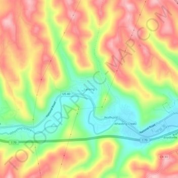
Name: Lansing topographic map, elevation, terrain.

Location: Lansing, Belmont County, Ohio, 43934, United States (40.05563 -80.81009 40.09563 -80.77009)

Average elevation: 974 ft

Minimum elevation: 640 ft

Maximum elevation: 1,280 ft

Belmont County trails, hiking, mountain biking, running and outdoor activities

Other topographic maps

Click on a map to view its topography, its elevation and its terrain.

Neffs

United States > Ohio > Belmont County > Neffs

Average elevation: 984 ft

Morristown

United States > Ohio > Belmont County

Average elevation: 1,227 ft

Flushing

United States > Ohio > Belmont County

Average elevation: 1,198 ft

Holloway

United States > Ohio > Belmont County

Average elevation: 1,027 ft

Brookside

United States > Ohio > Belmont County

Average elevation: 922 ft

Bridgeport

United States > Ohio > Belmont County

Average elevation: 801 ft

Bethesda

United States > Ohio > Belmont County

Average elevation: 1,234 ft

Belmont

United States > Ohio > Belmont County

Average elevation: 1,184 ft

Martins Ferry

United States > Ohio > Belmont County

Average elevation: 945 ft

Piedmont Lake

United States > Ohio > Belmont County

Average elevation: 1,053 ft

Yorkville

United States > Ohio > Belmont County

Average elevation: 840 ft

Powhatan Point

United States > Ohio > Belmont County

Average elevation: 791 ft

Shadyside

United States > Ohio > Belmont County

Average elevation: 804 ft

Gear up for your next adventure:

📦Dry Bags Set - Waterproof storage for electronics and clothes
🏕️Family Camping Gear - Essentials for group camping trips
🩳Quick‑Dry Hiking Shorts - Comfortable and quick‑dry shorts for summer hiking
🥇GPS Hiking Watch - Multi‑sport GPS watch with navigation and trail tracking
📚Navigation Handbooks - Master the art of reading topographic maps and using a compass

As an Amazon Associate, this site earns from qualifying purchases at no extra cost to you.