
Make a donation
Gear up for your next adventure:
As an Amazon Associate, this site earns from qualifying purchases at no extra cost to you.
Aue topographic map
Click on the map to display elevation.
Make a donation
Gear up for your next adventure:
As an Amazon Associate, this site earns from qualifying purchases at no extra cost to you.
About this map
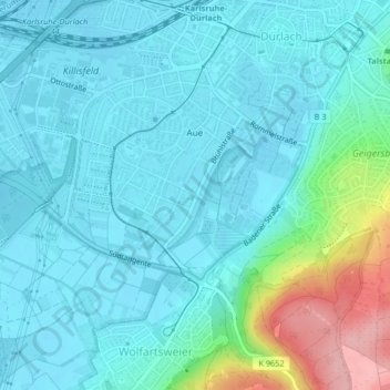
Name: Aue topographic map, elevation, terrain.
Location: Aue, Durlach, Karlsruhe, Baden-Württemberg, 76227, Deutschland (48.97939 8.44653 48.99748 8.47307)
Average elevation: 456 ft
Minimum elevation: 374 ft
Maximum elevation: 837 ft
Make a donation
Gear up for your next adventure:
As an Amazon Associate, this site earns from qualifying purchases at no extra cost to you.
Other topographic maps
Click on a map to view its topography, its elevation and its terrain.
Maxau
Deutschland > Baden-Württemberg > Karlsruhe
Ein Denkmal für Johann Gottfried Tulla, den Initiator und Planer der Rheinbegradigung, steht bei Rheinkilometer 360,9 auf Höhe des Rheinabschnittes, an dem 1817 die Arbeiten begonnen wurden.
Average elevation: 348 ft
Make a donation
Gear up for your next adventure:
As an Amazon Associate, this site earns from qualifying purchases at no extra cost to you.
Turmberg
Deutschland > Baden-Württemberg > Karlsruhe
Der Turmberg liegt im Grenzbereich vom Kraichgau zum Schwarzwald und gehört seit Januar 2021 zum Naturpark Schwarzwald Mitte/Nord. In der naturräumlichen Gliederung wird er dem Kraichgau zugerechnet. Daneben gibt es Darstellungen, die ihn als nördlichste Schwarzwaldhöhe ansehen. Der Berggipfel besteht,…
Average elevation: 528 ft