Geolocate

Ranna topographic map

Click on the map to display elevation.

About this map

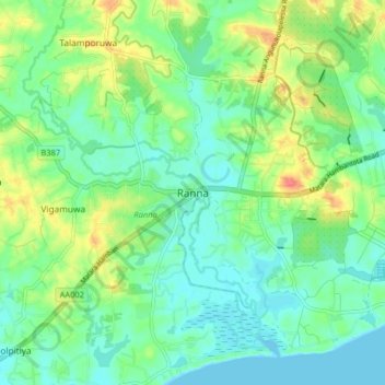
Name: Ranna topographic map, elevation, terrain.

Location: Ranna, Hambantota District, Southern Province, 82125, Sri Lanka (6.05701 80.83514 6.13701 80.91514)

Average elevation: 56 ft

Minimum elevation: -3 ft

Maximum elevation: 171 ft

Other topographic maps

Click on a map to view its topography, its elevation and its terrain.

Weligama

Sri Lanka > Southern Province

Weligama (Sinhala: වැලිගම, Tamil: வெலிகாமம்) is a town on the south coast of Sri Lanka, located in Matara District, Southern Province, Sri Lanka, governed by an Urban Council. The name Weligama, literally means "sandy village" which refers to the area's sandy sweep bay. It is…

Average elevation: 23 ft

Hambantota District

Sri Lanka > Southern Province

Average elevation: 358 ft

Hikkaduwa

Sri Lanka > Southern Province

Average elevation: 10 ft

Matara

Sri Lanka > Southern Province

Average elevation: 23 ft

DC

Sri Lanka > Southern Province > Hambantota

Average elevation: 56 ft

Polhena Beach

Sri Lanka > Southern Province > Polhena

Average elevation: 13 ft

Gear up for your next adventure:

👟Men's Trail Runners - Lightweight footwear for fast-paced exploration and light hiking
🗻Climbing Gear Basics - Essential gear for beginner climbers
🧦Merino Wool Socks - Moisture-wicking, blister-preventing socks for long treks
🪶Camping Sleeping Pad - Comfortable sleeping pad for backpacking
📦Dry Bags Set - Waterproof storage for electronics and clothes

As an Amazon Associate, this site earns from qualifying purchases at no extra cost to you.