
Thank you for supporting this site ❤️
Make a donation
Make a donation
Gear up for your next adventure:
As an Amazon Associate, this site earns from qualifying purchases at no extra cost to you.
Muodoslompolo topographic map
Click on the map to display elevation.
Thank you for supporting this site ❤️
Make a donation
Make a donation
Gear up for your next adventure:
As an Amazon Associate, this site earns from qualifying purchases at no extra cost to you.
About this map
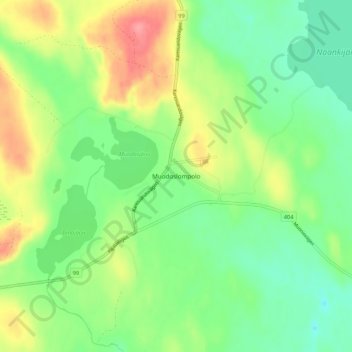
Name: Muodoslompolo topographic map, elevation, terrain.
Average elevation: 781 ft
Minimum elevation: 679 ft
Maximum elevation: 942 ft
Thank you for supporting this site ❤️
Make a donation
Make a donation
Gear up for your next adventure:
As an Amazon Associate, this site earns from qualifying purchases at no extra cost to you.
Other topographic maps
Click on a map to view its topography, its elevation and its terrain.
Abisko nationalpark
Permafrost is common in the national park, though permafrost at lower elevations is disappearing because of global warming and increased snowfall.
Average elevation: 2,428 ft