Geolocate

Bethlehem topographic map

Click on the map to display elevation.

About this map

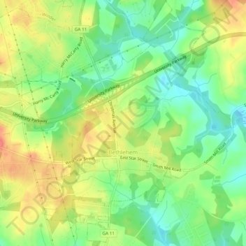
Name: Bethlehem topographic map, elevation, terrain.

Location: Bethlehem, Barrow County, Georgia, United States (33.91771 -83.72884 33.95742 -83.69164)

Average elevation: 846 ft

Minimum elevation: 755 ft

Maximum elevation: 951 ft

Barrow County trails, hiking, mountain biking, running and outdoor activities

Other topographic maps

Click on a map to view its topography, its elevation and its terrain.

Russell

United States > Georgia > Barrow County

Average elevation: 915 ft

Gear up for your next adventure:

🧤Tactile Hiking Gloves - Keep hands warm while operating GPS and smartphone screens
📻Weather Alert Radios - Stay informed of storm risks while off-the-grid
📌Outdoor GPS Map App - Apps and devices for digital topographic navigation
🧤Hiking Gloves - Protective gloves for rugged trails
👓Polarized Sunglasses - Outdoor sunglasses for glare reduction

As an Amazon Associate, this site earns from qualifying purchases at no extra cost to you.