Geolocate

Monkton topographic map

Click on the map to display elevation.

About this map

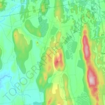
Name: Monkton topographic map, elevation, terrain.

Location: Monkton, Addison County, Vermont, 05469, United States (44.17394 -73.19680 44.28232 -73.07104)

Average elevation: 545 ft

Minimum elevation: 161 ft

Maximum elevation: 1,644 ft

Addison County trails, hiking, mountain biking, running and outdoor activities

Other topographic maps

Click on a map to view its topography, its elevation and its terrain.

South Lincoln

United States > Vermont > Addison County > Lincoln

Average elevation: 1,457 ft

Bread Loaf

United States > Vermont > Addison County > Ripton

Average elevation: 1,631 ft

Chimney Point

United States > Vermont > Addison County > Addison

Average elevation: 105 ft

South Mountain

United States > Vermont > Addison County > Bristol

Average elevation: 1,939 ft

Richville

United States > Vermont > Addison County > Shoreham

Average elevation: 322 ft

Bristol

United States > Vermont > Addison County > Bristol > Bristol

Average elevation: 876 ft

Gear up for your next adventure:

Camping Coffee Makers - Enjoy premium coffee at the summit or campsite
🛌Ultralight Sleeping Bags - Compact down bags for cold nights in the wilderness
🧺Microfiber Travel Towels - Compact and fast-drying towels for trail use
🧷Carabiner Set - Durable clips for gear attachment
🛰️Handheld GPS Units - Professional satellite navigators for precise backcountry mapping

As an Amazon Associate, this site earns from qualifying purchases at no extra cost to you.