Geolocate

Ferry topographic map

Click on the map to display elevation.

About this map

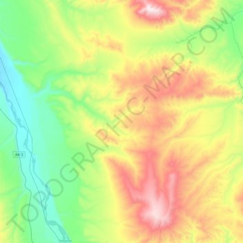
Name: Ferry topographic map, elevation, terrain.

Location: Ferry, Denali, Alaska, United States (63.95660 -149.16913 64.11940 -148.72137)

Average elevation: 2,080 ft

Minimum elevation: 902 ft

Maximum elevation: 4,140 ft

Denali trails, hiking, mountain biking, running and outdoor activities

Other topographic maps

Click on a map to view its topography, its elevation and its terrain.

Anderson

United States > Alaska > Denali > Anderson

Average elevation: 512 ft

Kantishna

United States > Alaska > Denali

Average elevation: 2,224 ft

Yanert Glacier

United States > Alaska > Denali

Average elevation: 5,587 ft

Igloo Mountain

United States > Alaska > Denali

Average elevation: 3,560 ft

Gear up for your next adventure:

🥘Titanium Cookware - Durable, featherlight pots and pans for backpacking
🛌Ultralight Sleeping Bags - Compact down bags for cold nights in the wilderness
🎒Waterproof Dry Bags - Keep your electronics and maps dry inside your pack
🪶Thermal Camp Blanket - Extra warmth for cold nights
🥾Women's Hiking Boots - Top-rated trail boots with ankle support and superior grip

As an Amazon Associate, this site earns from qualifying purchases at no extra cost to you.