Geolocate

Turin topographic map

Click on the map to display elevation.

About this map

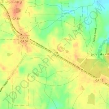
Name: Turin topographic map, elevation, terrain.

Location: Turin, Coweta County, Georgia, 30289, United States (33.31341 -84.64875 33.33886 -84.62550)

Average elevation: 896 ft

Minimum elevation: 817 ft

Maximum elevation: 945 ft

Coweta County trails, hiking, mountain biking, running and outdoor activities

Other topographic maps

Click on a map to view its topography, its elevation and its terrain.

East Newnan

United States > Georgia > Coweta County

Average elevation: 951 ft

Arnco Mills

United States > Georgia > Coweta County

Average elevation: 840 ft

Thomas Crossroads

United States > Georgia > Coweta County

Average elevation: 928 ft

McBride

United States > Georgia > Coweta County > Newnan

Average elevation: 919 ft

McCollum

United States > Georgia > Coweta County

Average elevation: 932 ft

Gear up for your next adventure:

🔪Outdoor Multitools - Essential survival tools for gear repair and field use
📶Satellite Messenger - Communication device off‑grid
👟Men's Trail Runners - Lightweight footwear for fast-paced exploration and light hiking
🎒Gear Packing Cubes - Organize your backpack efficiently
📚USA Hiking Guide Books - Top trail guides and map books

As an Amazon Associate, this site earns from qualifying purchases at no extra cost to you.