Geolocate

Ida topographic map

Click on the map to display elevation.

About this map

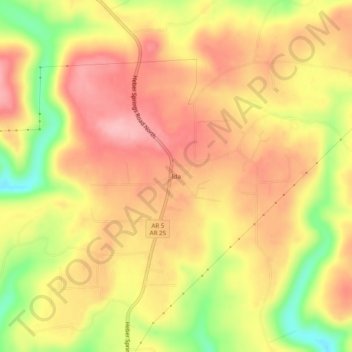
Name: Ida topographic map, elevation, terrain.

Location: Ida, Cleburne County, Arkansas, 72546, United States (35.56813 -91.94792 35.60813 -91.90792)

Average elevation: 925 ft

Minimum elevation: 646 ft

Maximum elevation: 1,099 ft

Cleburne County trails, hiking, mountain biking, running and outdoor activities

Other topographic maps

Click on a map to view its topography, its elevation and its terrain.

Higden

United States > Arkansas > Cleburne County

Average elevation: 499 ft

Concord

United States > Arkansas > Cleburne County

Average elevation: 974 ft

Gear up for your next adventure:

💧Water Purification System - Clean water on the trail with reliable purifiers
🌄Hiking Binoculars - Compact binoculars for scenic views and trail spotting
😴Insulated Sleeping Pads - Compact and warm pads for high-elevation camping
📻Weather Alert Radios - Stay informed of storm risks while off-the-grid
🎒Day Hiking Backpack - Lightweight backpack perfect for day trips and outdoor adventures

As an Amazon Associate, this site earns from qualifying purchases at no extra cost to you.