
Make a donation
Gear up for your next adventure:
As an Amazon Associate, this site earns from qualifying purchases at no extra cost to you.
Catawissa topographic map
Click on the map to display elevation.
Make a donation
Gear up for your next adventure:
As an Amazon Associate, this site earns from qualifying purchases at no extra cost to you.
About this map
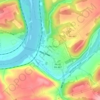
Name: Catawissa topographic map, elevation, terrain.
Location: Catawissa, Columbia County, Pennsylvania, United States (40.94558 -76.46857 40.96201 -76.45240)
Average elevation: 643 ft
Minimum elevation: 440 ft
Maximum elevation: 889 ft
Columbia County trails, hiking, mountain biking, running and outdoor activities
Make a donation
Gear up for your next adventure:
As an Amazon Associate, this site earns from qualifying purchases at no extra cost to you.
Other topographic maps
Click on a map to view its topography, its elevation and its terrain.
Mifflin Cross Roads
United States > Pennsylvania > Columbia County > Beaver Township
Average elevation: 1,024 ft
Make a donation
Gear up for your next adventure:
As an Amazon Associate, this site earns from qualifying purchases at no extra cost to you.
Byrnesville
United States > Pennsylvania > Columbia County > Conyngham Township
Average elevation: 1,325 ft
Hemlock Creek
United States > Pennsylvania > Columbia County > Buckhorn > Buckhorn
Average elevation: 679 ft