Geolocate

Jolly topographic map

Click on the map to display elevation.

About this map

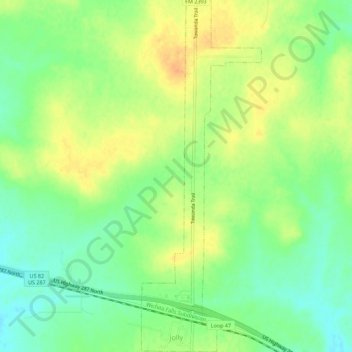
Name: Jolly topographic map, elevation, terrain.

Location: Jolly, Clay County, Texas, United States (33.86292 -98.35527 33.90938 -98.33616)

Average elevation: 984 ft

Minimum elevation: 925 ft

Maximum elevation: 1,040 ft

Clay County trails, hiking, mountain biking, running and outdoor activities

Other topographic maps

Click on a map to view its topography, its elevation and its terrain.

Charlie

United States > Texas > Clay County

Average elevation: 951 ft

Walton

United States > Texas > Clay County

Average elevation: 883 ft

Shannon

United States > Texas > Clay County

Average elevation: 1,053 ft

Gear up for your next adventure:

🧢Sun Protection Hats - Wide-brimmed and UPF-rated hats for high-altitude sun safety
🔊Portable Camp Speaker - Music and alerts at camp
🧦Merino Wool Socks - Moisture-wicking, blister-preventing socks for long treks
💧Water Filtration Bottles - Safely drink from streams and lakes while exploring
🏫Relief Map Kits - Hands-on tools for teaching landforms and elevation

As an Amazon Associate, this site earns from qualifying purchases at no extra cost to you.