
Adams Falls topographic map
Click on the map to display elevation.
About this map
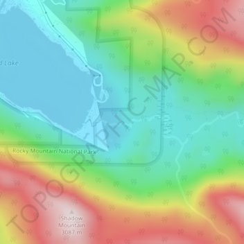
Name: Adams Falls topographic map, elevation, terrain.
Location: Adams Falls, Grand County, Colorado, United States (40.23650 -105.79801 40.23660 -105.79791)
Average elevation: 8,996 ft
Minimum elevation: 8,373 ft
Maximum elevation: 10,079 ft
Grand County trails, hiking, mountain biking, running and outdoor activities
Other topographic maps
Click on a map to view its topography, its elevation and its terrain.
Fraser
United States > Colorado > Grand County
Fraser is located in southeastern Grand County at 39°56′39″N 105°48′48″W / 39.94417°N 105.81333°W / 39.94417; -105.81333 (39.944158, -105.813355), at an elevation of 8,574 feet (2,613 m) above sea level. It is bordered to the south by the town of Winter Park and to the north by…
Average elevation: 8,845 ft
Hot Sulphur Springs
United States > Colorado > Grand County
Hot Sulphur Springs is a statutory town and the county seat of Grand County, Colorado, United States. The town is located near Byers Canyon between Granby and Kremmling, 95 miles (153 km) northwest of Denver and 30 miles (48 km) northwest of Winter Park. The town population was 687 at the 2020 census. Its…
Average elevation: 8,025 ft