
Ottawa topographic map
Interactive map
Click on the map to display elevation.
About this map
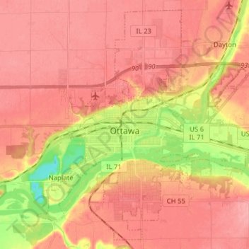
Name: Ottawa topographic map, elevation, terrain.
Location: Ottawa, LaSalle County, Illinois, 61350, United States (41.30969 -88.89043 41.39794 -88.76318)
Average elevation: 568 ft
Minimum elevation: 371 ft
Maximum elevation: 656 ft
Other topographic maps
Click on a map to view its topography, its elevation and its terrain.
Seneca
United States > Illinois > LaSalle County
Seneca, LaSalle County, Illinois, United States
Average elevation: 591 ft
Peru
United States > Illinois > LaSalle County
Peru, LaSalle County, Illinois, 61354, United States
Average elevation: 591 ft
LaSalle
United States > Illinois > LaSalle County
LaSalle, LaSalle County, Illinois, 61301, United States
Average elevation: 591 ft
Lower Fox River - Blakes Landing Nature Preserve
United States > Illinois > LaSalle County > Blakes
Lower Fox River - Blakes Landing Nature Preserve, Blakes, LaSalle County, Illinois, 60557, United States
Average elevation: 597 ft
Starved Rock
United States > Illinois > LaSalle County
Starved Rock, LaSalle County, Illinois, 61373, United States
Average elevation: 525 ft
Marseilles
United States > Illinois > LaSalle County > Marseilles
Marseilles, LaSalle County, Illinois, 61341, United States
Average elevation: 620 ft
North Utica
United States > Illinois > LaSalle County
North Utica, LaSalle County, Illinois, 61373, United States
Average elevation: 574 ft
Oglesby
United States > Illinois > LaSalle County
Oglesby, LaSalle County, Illinois, 61348, United States
Average elevation: 581 ft
Earlville
United States > Illinois > LaSalle County
Earlville, LaSalle County, Illinois, 60518, United States
Average elevation: 702 ft
Grand Ridge
United States > Illinois > LaSalle County
Grand Ridge, LaSalle County, Illinois, United States
Average elevation: 643 ft