
Make a donation
Gear up for your next adventure:
As an Amazon Associate, this site earns from qualifying purchases at no extra cost to you.
Bovekerke topographic map
Click on the map to display elevation.
Make a donation
Gear up for your next adventure:
As an Amazon Associate, this site earns from qualifying purchases at no extra cost to you.
Bovekerke
Bovekerke behoort tot Zandig Vlaanderen en het gebied heeft een hoogte van 10 tot 21 meter. De kom ligt op ongeveer 15 meter hoogte. De beken wateren af naar het zuidwesten, in de richting van de Handzamevaart. Ten noorden van het dorp vindt men het Arboretum van Koekelare en het Koekelarebos.
Make a donation
Gear up for your next adventure:
As an Amazon Associate, this site earns from qualifying purchases at no extra cost to you.
About this map
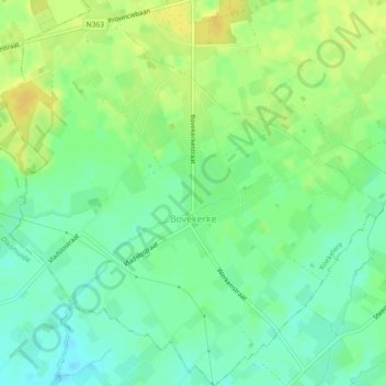
Name: Bovekerke topographic map, elevation, terrain.
Location: Bovekerke, Koekelare, Diksmuide, West-Vlaanderen, België (51.04186 2.94059 51.07048 2.98594)
Average elevation: 43 ft
Minimum elevation: 7 ft
Maximum elevation: 82 ft
Make a donation
Gear up for your next adventure:
As an Amazon Associate, this site earns from qualifying purchases at no extra cost to you.
Other topographic maps
Click on a map to view its topography, its elevation and its terrain.
Make a donation
Gear up for your next adventure:
As an Amazon Associate, this site earns from qualifying purchases at no extra cost to you.