Geolocate

Sandy Gulch topographic map

Click on the map to display elevation.

About this map
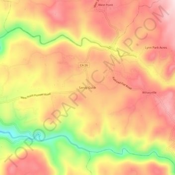
Name: Sandy Gulch topographic map, elevation, terrain.

Location: Sandy Gulch, Calaveras County, California, 95255, United States (38.36019 -120.55270 38.40019 -120.51270)

Average elevation: 2,559 ft

Minimum elevation: 1,893 ft

Maximum elevation: 2,963 ft

Calaveras County trails, hiking, mountain biking, running and outdoor activities

Other topographic maps

Click on a map to view its topography, its elevation and its terrain.

Mokelumne Hill

United States > California > Calaveras County

Average elevation: 1,312 ft

San Andreas

United States > California > Calaveras County

Average elevation: 1,171 ft

Forest Meadows

United States > California > Calaveras County

Average elevation: 2,907 ft

Wallace

United States > California > Calaveras County

Average elevation: 276 ft

Vallecito

United States > California > Calaveras County

Average elevation: 1,726 ft

Rail Road Flat

United States > California > Calaveras County

This historic mining town, elevation 2,600 feet (788 m), was named after primitive mule-drawn ore cars used here. There was never actually a railroad here. The town was established in 1849. It was the site of an Indian council as well as the center of rich placer and quartz mining. Its largest producer was the…

Average elevation: 2,726 ft

Gear up for your next adventure:

🧦Hiking Socks - Comfortable socks to prevent blisters on long hikes
🛌Ultralight Sleeping Bags - Compact down bags for cold nights in the wilderness
🔦LED Headlamp - Bright and durable LED headlamp for night navigation
📦Gear Storage Bags - Organize and protect outdoor equipment
🥇GPS Hiking Watch - Multi‑sport GPS watch with navigation and trail tracking

As an Amazon Associate, this site earns from qualifying purchases at no extra cost to you.