
Make a donation
Gear up for your next adventure:
As an Amazon Associate, this site earns from qualifying purchases at no extra cost to you.
Wenzenbach topographic map
Click on the map to display elevation.
Make a donation
Gear up for your next adventure:
As an Amazon Associate, this site earns from qualifying purchases at no extra cost to you.
Wenzenbach
Höhenlage: zwischen 320 und 475 m ü. NHN
Make a donation
Gear up for your next adventure:
As an Amazon Associate, this site earns from qualifying purchases at no extra cost to you.
About this map
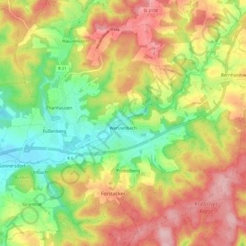
Name: Wenzenbach topographic map, elevation, terrain.
Location: Wenzenbach, Landkreis Regensburg, Bayern, 93173, Deutschland (49.04652 12.13268 49.10978 12.23505)
Average elevation: 1,414 ft
Minimum elevation: 1,115 ft
Maximum elevation: 1,729 ft
Make a donation
Gear up for your next adventure:
As an Amazon Associate, this site earns from qualifying purchases at no extra cost to you.
Other topographic maps
Click on a map to view its topography, its elevation and its terrain.
Kleinetzenberg
Deutschland > Bayern > Landkreis Regensburg > Großetzenberg
Average elevation: 1,463 ft
Make a donation
Gear up for your next adventure:
As an Amazon Associate, this site earns from qualifying purchases at no extra cost to you.
Make a donation
Gear up for your next adventure:
As an Amazon Associate, this site earns from qualifying purchases at no extra cost to you.
Make a donation
Gear up for your next adventure:
As an Amazon Associate, this site earns from qualifying purchases at no extra cost to you.
Hainsacker
Deutschland > Bayern > Landkreis Regensburg
Altenried | Aschach | Baiern | Benhof | Einhausen | Geiersberg | Gewald | Hainsacker | Harreshof | Hohensand | Hönighausen | Kareth | Kaulhausen | Knieschlag | Landlhof | Lappersdorf | Lorenzen | Oppersdorf | Pielmühle | Rehthal | Rodau | Schinderwies | Schwaighausen | Schwärz | Schwerdnermühle | Steinhof…
Average elevation: 1,319 ft
Make a donation
Gear up for your next adventure:
As an Amazon Associate, this site earns from qualifying purchases at no extra cost to you.
Wörth an der Donau
Deutschland > Bayern > Landkreis Regensburg > Wörth an der Donau > Wörth an der Donau
Average elevation: 1,243 ft
Make a donation
Gear up for your next adventure:
As an Amazon Associate, this site earns from qualifying purchases at no extra cost to you.
Wichenbach
Deutschland > Bayern > Landkreis Regensburg > Wörth an der Donau > Tiefenthal
Average elevation: 1,234 ft
Make a donation
Gear up for your next adventure:
As an Amazon Associate, this site earns from qualifying purchases at no extra cost to you.
Oberachdorf
Deutschland > Bayern > Landkreis Regensburg > Wörth an der Donau
Average elevation: 1,109 ft
Make a donation
Gear up for your next adventure:
As an Amazon Associate, this site earns from qualifying purchases at no extra cost to you.
Penk
Deutschland > Bayern > Landkreis Regensburg > Nittendorf > Etterzhausen
Average elevation: 1,358 ft
Make a donation
Gear up for your next adventure:
As an Amazon Associate, this site earns from qualifying purchases at no extra cost to you.
Make a donation
Gear up for your next adventure:
As an Amazon Associate, this site earns from qualifying purchases at no extra cost to you.
Make a donation
Gear up for your next adventure:
As an Amazon Associate, this site earns from qualifying purchases at no extra cost to you.
Make a donation
Gear up for your next adventure:
As an Amazon Associate, this site earns from qualifying purchases at no extra cost to you.
Make a donation
Gear up for your next adventure:
As an Amazon Associate, this site earns from qualifying purchases at no extra cost to you.
Make a donation
Gear up for your next adventure:
As an Amazon Associate, this site earns from qualifying purchases at no extra cost to you.
Danersdorf
Deutschland > Bayern > Landkreis Regensburg > Regenstauf > Gnadenhof
Average elevation: 1,581 ft
Make a donation
Gear up for your next adventure:
As an Amazon Associate, this site earns from qualifying purchases at no extra cost to you.
Wenzenbach
Deutschland > Bayern > Landkreis Regensburg > Probstberg > Zeitlhof
Average elevation: 1,276 ft
Holzheim am Forst
Deutschland > Bayern > Landkreis Regensburg > Holzheim am Forst > Holzheim am Forst
Average elevation: 1,283 ft
Make a donation
Gear up for your next adventure:
As an Amazon Associate, this site earns from qualifying purchases at no extra cost to you.
Kollersried
Deutschland > Bayern > Landkreis Regensburg > Hemau > Laufenthal > Kollersried
Average elevation: 1,644 ft
Neuhaus
Deutschland > Bayern > Landkreis Regensburg > Regenstauf > Diesenbach
Average elevation: 1,198 ft
Make a donation
Gear up for your next adventure:
As an Amazon Associate, this site earns from qualifying purchases at no extra cost to you.
Make a donation
Gear up for your next adventure:
As an Amazon Associate, this site earns from qualifying purchases at no extra cost to you.