
Undorf topographic map
Click on the map to display elevation.
About this map
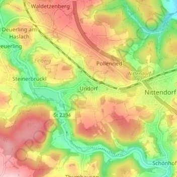
Name: Undorf topographic map, elevation, terrain.
Average elevation: 1,417 ft
Minimum elevation: 1,125 ft
Maximum elevation: 1,690 ft
Other topographic maps
Click on a map to view its topography, its elevation and its terrain.
Wörth an der Donau
Deutschland > Bayern > Landkreis Regensburg
In Wörth treffen zwei unterschiedliche Naturräume aufeinander. Der bergige Falkensteiner Vorwald, ein Teil des Bayerischen Waldes, im Norden und die südlich angrenzende Ebene des Gäubodens (Dungau). Hier durchfließt die Wiesent den Ortsteil Oberachdorf und mündet in den Donaualtarm der Gmünder Au. Fast…
Average elevation: 1,375 ft
Wenzenbach
Deutschland > Bayern > Landkreis Regensburg > Probstberg > Zeitlhof
Average elevation: 1,276 ft
Wenzenbach
Deutschland > Bayern > Landkreis Regensburg
Höhenlage: zwischen 320 und 475 m ü. NHN
Average elevation: 1,414 ft
Kallmünz
Deutschland > Bayern > Landkreis Regensburg
Domenico Quaglio war im Auftrag des bayerischen Königs Ludwig I. auf der Suche nach einem geeigneten Standort für die Befreiungshalle in Kallmünz und nahm eine Anhöhe gegenüber der Burgruine in die engere Auswahl.
Average elevation: 1,355 ft
93086
Deutschland > Bayern > Landkreis Regensburg > Wörth an der Donau > Hungersacker
Average elevation: 1,450 ft
Pettendorf
Deutschland > Bayern > Landkreis Regensburg
Im 2. Jahrhundert verlief die Grenze des Römischen Reiches am südlichen Rand der heutigen Gemeinde Pettendorf. Auf der gegenüberliegenden Donauseite von Mariaort befand sich das Prüfeninger Kleinkastell, das um das Jahr 179 erbaut wurde und wohl zur Beobachtung von Germanenvorstößen aus dem Pettendorfer…
Average elevation: 1,332 ft
Wiesent
Deutschland > Bayern > Landkreis Regensburg
Im Zuge der Gebietsreform in Bayern wurden am 1. Januar 1972 die Gemeinden Dietersweg und Kruckenberg jeweils mit allen ihren Gemeindeteilen eingegliedert. Dietersweg brachte die Gemeindeteile Dietersweg, Eckenzell, Eidenzell, Grafenöd, Heilsberg, Hermannsöd, Höhenberg, Kirnberg, Mitterroith, Neuhaus,…
Average elevation: 1,401 ft
93138
Deutschland > Bayern > Landkreis Regensburg > Lappersdorf > Hainsacker > Grafenhof
Average elevation: 1,329 ft
Lappersdorf
Deutschland > Bayern > Landkreis Regensburg
Altenried | Aschach | Baiern | Benhof | Einhausen | Geiersberg | Gewald | Hainsacker | Harreshof | Hohensand | Hönighausen | Kareth | Kaulhausen | Knieschlag | Landlhof | Lappersdorf | Lorenzen | Oppersdorf | Pielmühle | Rehthal | Rodau | Schinderwies | Schwaighausen | Schwärz | Schwerdnermühle | Steinhof…
Average elevation: 1,243 ft
93170
Deutschland > Bayern > Landkreis Regensburg > Bernhardswald > Finsing
Average elevation: 1,522 ft
Schierling
Deutschland > Bayern > Landkreis Regensburg
Am 22. April 1809 besiegte Napoleon mit seinen Verbündeten Österreich in der „Schlacht bei Eggmühl“ entscheidend. Diese Schlacht in der Laberaue und auf den angrenzenden Höhen wurde von Napoleon später als seine größte Bewährungsprobe bezeichnet. Seit 1909 steht ein Löwendenkmal, mahnend an die…
Average elevation: 1,348 ft
Duggendorf
Deutschland > Bayern > Landkreis Regensburg
Auf dem Gebiet der Gemeinde liegt der Burgstall Lichtenroth, eine abgegangene Höhenburg.
Average elevation: 1,450 ft
Brennberg
Deutschland > Bayern > Landkreis Regensburg
Im Falkensteiner Vorwald herrscht mitteleuropäisches Kontinentalklima. In den Wintermonaten von Dezember bis März herrscht besonders über 500–600 m raues Klima mit anhaltend geschlossener Schneedecke. Bei Süd- und Westwind stauen sich die vom flachen Donautal kommenden Wolken in den Hängen des…
Average elevation: 1,795 ft
Wörth an der Donau
Deutschland > Bayern > Landkreis Regensburg
In der Gemeinde treffen zwei unterschiedliche Naturräume aufeinander. Der bergige Falkensteiner Vorwald, ein Teil des Bayerischen Waldes im Norden und die südlich angrenzende Ebene des Gäubodens (Dungau). Dort durchfließt die Wiesent den Ortsteil Oberachdorf und mündet in den Donaualtarm der Gmünder Au.…
Average elevation: 1,375 ft