Geolocate

Tamarin topographic map

Click on the map to display elevation.

About this map

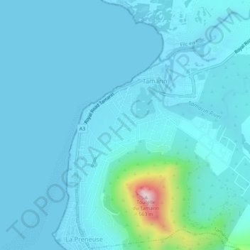
Name: Tamarin topographic map, elevation, terrain.

Location: Tamarin, Black River, Outer islands of Mauritius, 90503, Mauritius (-20.34922 57.35768 -20.30922 57.39768)

Average elevation: 118 ft

Minimum elevation: -10 ft

Maximum elevation: 1,759 ft

Other topographic maps

Click on a map to view its topography, its elevation and its terrain.

Le Morne VCA

Mauritius > Black River

Average elevation: 269 ft

Flic en Flac

Mauritius > Black River

Average elevation: 85 ft

Tamarin River

Mauritius > Black River > Tamarin

Average elevation: 400 ft

Tamarin

Mauritius > Black River

Average elevation: 174 ft

Bambous

Mauritius > Black River

Average elevation: 512 ft

Gear up for your next adventure:

🧯Emergency Survival Kit - All‑in‑one survival essentials for the backcountry
🛡️Bear Spray Outdoor - Protection in bear country hikes
🌎3D Topographic Globes - Raised relief globes for a tactile understanding of geography
🎒Trekking Poles - Sturdy poles for balance and stability on rough terrain
🧭Compass with Lanyard - Easy‑carry compass for navigation

As an Amazon Associate, this site earns from qualifying purchases at no extra cost to you.