Geolocate

Tamarin topographic map

Click on the map to display elevation.

About this map

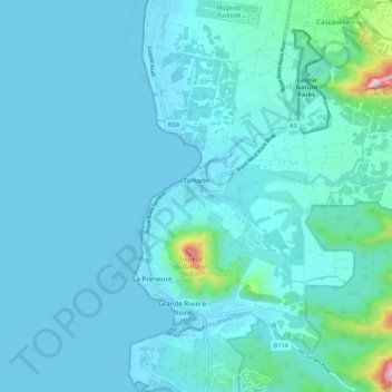
Name: Tamarin topographic map, elevation, terrain.

Location: Tamarin, Black River, Mauritius (-20.36336 57.36262 -20.30302 57.47027)

Average elevation: 174 ft

Minimum elevation: 0 ft

Maximum elevation: 2,028 ft

Other topographic maps

Click on a map to view its topography, its elevation and its terrain.

Flic en Flac

Mauritius > Black River > Flic en Flac VCA

Average elevation: 72 ft

Richelieu

Mauritius > Black River > Richelieu VCA, West

Average elevation: 253 ft

Cascavelle

Mauritius > Black River > Cascavelle VCA West

Average elevation: 597 ft

Tamarin

Mauritius > Black River > Tamarin VCA

Average elevation: 118 ft

Tamarin River

Mauritius > Black River > Tamarin

Average elevation: 400 ft

Chamarel

Mauritius > Black River

Chamarel is a village located in the western hills on the west coast of Mauritius at an elevation of about 850 feet (260 m) between Savanne and the Black river districts where the cascades are formed on the River du Capano flowing through an "amphitheater of abrupt rocks". It is a wooded plateau. The village…

Average elevation: 988 ft

Tamarin

Mauritius > Black River

Average elevation: 118 ft

La Preneuse

Mauritius > Black River > La Preneuse

Average elevation: 148 ft

La Gaulette

Mauritius > Black River

Average elevation: 262 ft

Gear up for your next adventure:

🔌USB Car Charger - Car charger for on‑the‑go power needs
🔭Telescopic Hiking Pole - Adjustable pole for hiking stability
🧯Portable Fire Pit - Compact fire pit for camping spots
🌄Hiking Binoculars - Compact binoculars for scenic views and trail spotting
🔋Solar Power Banks - Keep your GPS and phone charged in remote wilderness areas

As an Amazon Associate, this site earns from qualifying purchases at no extra cost to you.