Geolocate

Tovil topographic map

Click on the map to display elevation.

About this map

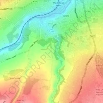
Name: Tovil topographic map, elevation, terrain.

Location: Tovil, Maidstone, Kent, England, United Kingdom (51.24690 0.49671 51.26674 0.52325)

Average elevation: 177 ft

Minimum elevation: 23 ft

Maximum elevation: 331 ft

Other topographic maps

Click on a map to view its topography, its elevation and its terrain.

Bletchingly

United Kingdom > England > Kent > Maidstone

Average elevation: 121 ft

Detling Hill

United Kingdom > England > Kent > Maidstone

Average elevation: 499 ft

Mote Park

United Kingdom > England > Kent > Maidstone > Otham

Average elevation: 171 ft

Broomfield

United Kingdom > England > Kent > Maidstone > Leeds

Average elevation: 315 ft

Langley Park

United Kingdom > England > Kent > Maidstone > Langley

Average elevation: 315 ft

Bicknor Wood

United Kingdom > England > Kent > Maidstone > Otham

Average elevation: 279 ft

Laddingford

United Kingdom > England > Kent > Maidstone > Yalding

Average elevation: 46 ft

Kingswood

United Kingdom > England > Kent > Maidstone

Average elevation: 358 ft

East Lenham

United Kingdom > England > Kent > Maidstone > Lenham

Average elevation: 417 ft

Linton

United Kingdom > England > Kent > Maidstone

Average elevation: 233 ft

Liverton Street

United Kingdom > England > Kent > Maidstone > Grafty Green

Average elevation: 335 ft

Westfield Sole

United Kingdom > England > Kent > Maidstone

Average elevation: 476 ft

Lenham Heath

United Kingdom > England > Kent > Maidstone

Average elevation: 315 ft

Leadingcross Green

United Kingdom > England > Kent > Maidstone > Lenham

Average elevation: 387 ft

Bletchenden

United Kingdom > England > Kent > Maidstone > Headcorn

Average elevation: 79 ft

Walderslade Woods

United Kingdom > England > Kent > Maidstone

Average elevation: 509 ft

Harpole

United Kingdom > England > Kent > Maidstone > Detling

Average elevation: 338 ft

Weavering Park

United Kingdom > England > Kent > Maidstone > Grove Green

Average elevation: 184 ft

Eyhorne Street

United Kingdom > England > Kent > Maidstone > Hollingbourne

Average elevation: 295 ft

Gear up for your next adventure:

Camping Coffee Makers - Enjoy premium coffee at the summit or campsite
📦Dry Bags Set - Waterproof storage for electronics and clothes
🥩Freeze-Dried Meals - Nutritious and lightweight food for remote expeditions
📷Action Cameras - Rugged cameras to document your journeys across rugged terrain
🧷Carabiner Set - Durable clips for gear attachment

As an Amazon Associate, this site earns from qualifying purchases at no extra cost to you.