Geolocate

Big Lake topographic map

Click on the map to display elevation.

About this map

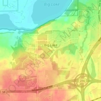
Name: Big Lake topographic map, elevation, terrain.

Location: Big Lake, Edmonton, Alberta, Canada (53.56981 -113.71384 53.59967 -113.65153)

Average elevation: 2,221 ft

Minimum elevation: 2,126 ft

Maximum elevation: 2,310 ft

Other topographic maps

Click on a map to view its topography, its elevation and its terrain.

landslide

Canada > Alberta > Edmonton

Average elevation: 2,192 ft

William Hawrelak Park

Canada > Alberta > Edmonton

Average elevation: 2,129 ft

Horseshoe Lake

Canada > Alberta > Edmonton

Average elevation: 2,231 ft

Ormsby Park

Canada > Alberta > Edmonton

Average elevation: 2,257 ft

Gear up for your next adventure:

🧢Sun Protection Hats - Wide-brimmed and UPF-rated hats for high-altitude sun safety
🧦Merino Wool Socks - Moisture-wicking, blister-preventing socks for long treks
📌Outdoor GPS Map App - Apps and devices for digital topographic navigation
🛠️Backpacking Tool Kit - Essential toolkit for outdoor repairs
💧Water Filtration Bottles - Safely drink from streams and lakes while exploring

As an Amazon Associate, this site earns from qualifying purchases at no extra cost to you.