Geolocate

Trasquera topographic map

Click on the map to display elevation.

About this map

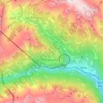
Name: Trasquera topographic map, elevation, terrain.

Location: Trasquera, Verbano-Cusio-Ossola, Piedmont, 28868, Italy (46.17631 8.13888 46.26473 8.23618)

Average elevation: 5,164 ft

Minimum elevation: 1,407 ft

Maximum elevation: 9,534 ft

Other topographic maps

Click on a map to view its topography, its elevation and its terrain.

Iselle

Italy > Piedmont > Verbano-Cusio-Ossola > Trasquera

Average elevation: 4,419 ft

Gear up for your next adventure:

🖼️Topo Map Wall Art - Decorative topographic prints of famous peaks and regions
🦶Carbon Trekking Poles - Reduce knee impact on steep descents with ultra-light poles
🌎3D Topographic Globes - Raised relief globes for a tactile understanding of geography
🔥Fast-Boil Camping Stoves - Efficient cooking systems for quick trail meals
💧Water Purification System - Clean water on the trail with reliable purifiers

As an Amazon Associate, this site earns from qualifying purchases at no extra cost to you.