Geolocate

Iselle topographic map

Click on the map to display elevation.

👉 Easily get elevation data in JSON, GeoTIFF and KML formats using Elevation API
Thank you for supporting this site ❤️
Make a donation

About this map

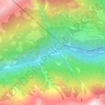
Name: Iselle topographic map, elevation, terrain.

Location: Iselle, Trasquera, Verbano-Cusio-Ossola, Piedmont, 28868, Italy (46.18528 8.17211 46.22528 8.21211)

Average elevation: 4,419 ft

Minimum elevation: 1,896 ft

Maximum elevation: 7,822 ft

Other topographic maps

Click on a map to view its topography, its elevation and its terrain.

Trasquera

Italy > Piedmont > Verbano-Cusio-Ossola > Trasquera

Average elevation: 5,164 ft

Gear up for your next adventure:

🌡️Portable Weather Meter - Track weather conditions on the trail
🥩Freeze-Dried Meals - Nutritious and lightweight food for remote expeditions
🔭Stargazing Telescopes - Perfect for camping in low-light pollution areas shown on maps
🌄Hiking Binoculars - Compact binoculars for scenic views and trail spotting
🥾Women's Hiking Boots - Top-rated trail boots with ankle support and superior grip

As an Amazon Associate, this site earns from qualifying purchases at no extra cost to you.