
Castle Point topographic map
Click on the map to display elevation.
About this map
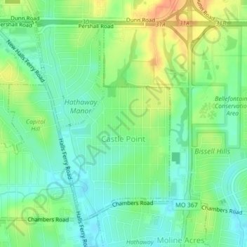
Name: Castle Point topographic map, elevation, terrain.
Location: Castle Point, Saint Louis County, Missouri, United States (38.74908 -90.25728 38.77044 -90.24165)
Average elevation: 505 ft
Minimum elevation: 449 ft
Maximum elevation: 591 ft
Saint Louis County trails, hiking, mountain biking, running and outdoor activities
Other topographic maps
Click on a map to view its topography, its elevation and its terrain.
Creve Coeur Lake
United States > Missouri > Saint Louis County > Maryland Heights
Average elevation: 492 ft
Jefferson Barracks
United States > Missouri > Saint Louis County > Jefferson Barracks
Average elevation: 459 ft
Simpson Park Lake
United States > Missouri > Saint Louis County > Valley Park
Average elevation: 453 ft
Sioux Passage Park
United States > Missouri > Saint Louis County > Old Jamestown > Possum Hollow
Average elevation: 492 ft
Pattonville
United States > Missouri > Saint Louis County > Bridgeton > Pattonville
Average elevation: 571 ft
Greentree Park
United States > Missouri > Saint Louis County > Kirkwood > Osage Hills
Average elevation: 495 ft