
Dymock topographic map
Click on the map to display elevation.
About this map
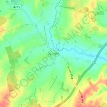
Name: Dymock topographic map, elevation, terrain.
Average elevation: 164 ft
Minimum elevation: 85 ft
Maximum elevation: 295 ft
Other topographic maps
Click on a map to view its topography, its elevation and its terrain.
Redmarley D'Abitot
United Kingdom > England > Gloucestershire > Forest of Dean
Average elevation: 151 ft
Newent Woods
United Kingdom > England > Gloucestershire > Forest of Dean > May Hill
Average elevation: 515 ft
Speech House Lake
United Kingdom > England > Gloucestershire > Forest of Dean
Average elevation: 486 ft
Newland
United Kingdom > England > Gloucestershire > Forest of Dean > Newland
Average elevation: 495 ft
Westbury-on-Severn
United Kingdom > England > Gloucestershire > Forest of Dean
Average elevation: 82 ft
Aylburton
United Kingdom > England > Gloucestershire > Forest of Dean > Aylburton
Average elevation: 121 ft
Lydney Harbour
United Kingdom > England > Gloucestershire > Forest of Dean > Lydney > Naas
Average elevation: 23 ft
Land Grove
United Kingdom > England > Gloucestershire > Forest of Dean > Mitcheldean
Average elevation: 515 ft
Coleford
United Kingdom > England > Gloucestershire > Forest of Dean > Coleford
Average elevation: 633 ft
Cinderford
United Kingdom > England > Gloucestershire > Forest of Dean > Littledean
Average elevation: 568 ft