
Newent topographic map
Click on the map to display elevation.
About this map
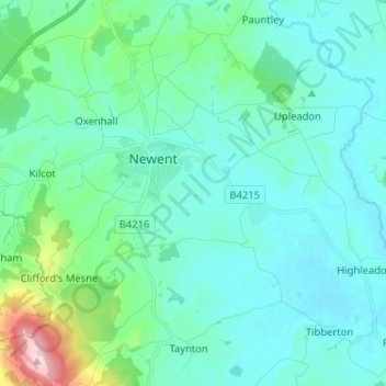
Name: Newent topographic map, elevation, terrain.
Average elevation: 177 ft
Minimum elevation: 26 ft
Maximum elevation: 994 ft
Other topographic maps
Click on a map to view its topography, its elevation and its terrain.
Joyford
United Kingdom > England > Gloucestershire > Forest of Dean > Berry Hill
Average elevation: 617 ft
Bream Meend
United Kingdom > England > Gloucestershire > Forest of Dean > Bream
Average elevation: 459 ft
Highbury
United Kingdom > England > Gloucestershire > Forest of Dean > Lydney > Allaston
Average elevation: 213 ft
Grange Village
United Kingdom > England > Gloucestershire > Forest of Dean > Littledean
Average elevation: 322 ft
Saunders Green
United Kingdom > England > Gloucestershire > Forest of Dean > Whitecroft
Average elevation: 364 ft
Bakers Hill
United Kingdom > England > Gloucestershire > Forest of Dean > Broadwell
Average elevation: 640 ft
Lydney Hub
United Kingdom > England > Gloucestershire > Forest of Dean > Lydney > Allaston > Tutnalls
Average elevation: 138 ft
Newent Woods
United Kingdom > England > Gloucestershire > Forest of Dean > May Hill
Average elevation: 515 ft
The Pludds
United Kingdom > England > Gloucestershire > Forest of Dean > Ruardean
Average elevation: 558 ft
Joys Green
United Kingdom > England > Gloucestershire > Forest of Dean > Upper Lydbrook
Average elevation: 466 ft
Newnham on Severn
United Kingdom > England > Gloucestershire > Forest of Dean
Average elevation: 180 ft
Plump Hill
United Kingdom > England > Gloucestershire > Forest of Dean > Abenhall > Plump Hill
Average elevation: 640 ft
Crumpmeadow Inclosure
United Kingdom > England > Gloucestershire > Forest of Dean > Cinderford
Average elevation: 548 ft
Lower Berry Hill
United Kingdom > England > Gloucestershire > Forest of Dean > Berry Hill
Average elevation: 633 ft
Yorkley Wood
United Kingdom > England > Gloucestershire > Forest of Dean > Pillowell > Yorkley Bottom
Average elevation: 400 ft
Fossil Beach
United Kingdom > England > Gloucestershire > Forest of Dean > Sedbury
Average elevation: 46 ft
Hope Valley
United Kingdom > England > Gloucestershire > Forest of Dean > Lydney > Aylburton
Average elevation: 200 ft
Symonds Yat Rock
United Kingdom > England > Gloucestershire > Forest of Dean
Average elevation: 322 ft
Brand Green
United Kingdom > England > Gloucestershire > Forest of Dean > Pauntley
Average elevation: 154 ft
Lower Soudley
United Kingdom > England > Gloucestershire > Forest of Dean > Upper Soudley
Average elevation: 390 ft
Poolway
United Kingdom > England > Gloucestershire > Forest of Dean > Coleford
Average elevation: 646 ft
Speech House Lake
United Kingdom > England > Gloucestershire > Forest of Dean
Average elevation: 486 ft
Tutnalls
United Kingdom > England > Gloucestershire > Forest of Dean > Lydney
Average elevation: 102 ft
Green Bottom
United Kingdom > England > Gloucestershire > Forest of Dean > Popes Hill
Average elevation: 492 ft
Broadoak
United Kingdom > England > Gloucestershire > Forest of Dean > Newnham on Severn
Average elevation: 98 ft
The Scarr
United Kingdom > England > Gloucestershire > Forest of Dean > Newent
Average elevation: 180 ft
Plump Hill
United Kingdom > England > Gloucestershire > Forest of Dean > Abenhall
Average elevation: 564 ft
Lydney Harbour
United Kingdom > England > Gloucestershire > Forest of Dean > Lydney > Naas
Average elevation: 23 ft
Land Grove
United Kingdom > England > Gloucestershire > Forest of Dean > Mitcheldean
Average elevation: 515 ft
Ruardean Woodside
United Kingdom > England > Gloucestershire > Forest of Dean > Ruardean
Average elevation: 610 ft
Ruardean Hill
United Kingdom > England > Gloucestershire > Forest of Dean > Drybrook
Average elevation: 669 ft
Glasshouse
United Kingdom > England > Gloucestershire > Forest of Dean > May Hill
Average elevation: 361 ft
Green Bottom
United Kingdom > England > Gloucestershire > Forest of Dean > Littledean
Average elevation: 492 ft
Joys Green
United Kingdom > England > Gloucestershire > Forest of Dean > Upper Lydbrook
Average elevation: 466 ft
Ruddle
United Kingdom > England > Gloucestershire > Forest of Dean > Newnham on Severn
Average elevation: 190 ft