Geolocate

Pierceton topographic map

Click on the map to display elevation.

About this map

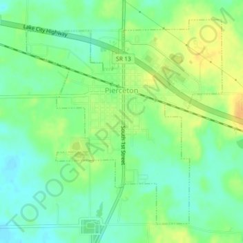
Name: Pierceton topographic map, elevation, terrain.

Location: Pierceton, Kosciusko County, Indiana, United States (41.18547 -85.71962 41.20818 -85.69069)

Average elevation: 919 ft

Minimum elevation: 873 ft

Maximum elevation: 971 ft

Kosciusko County trails, hiking, mountain biking, running and outdoor activities

Other topographic maps

Click on a map to view its topography, its elevation and its terrain.

Warsaw

United States > Indiana > Kosciusko County > Warsaw > Warsaw

Average elevation: 837 ft

Atwood

United States > Indiana > Kosciusko County

Average elevation: 807 ft

Gear up for your next adventure:

🎁Geography Themed Gifts - Unique gift ideas for map lovers and geography enthusiasts
🧴Hand Sanitizer - Keep hands clean while hiking
🌧️Backpack Rain Cover - Keep gear dry in wet weather
🔋Rechargeable Batteries - Power up your outdoor devices
🏕️Tent Footprint - Protect your tent base from wear

As an Amazon Associate, this site earns from qualifying purchases at no extra cost to you.