Geolocate

Spencer topographic map

Click on the map to display elevation.

About this map

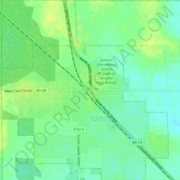
Name: Spencer topographic map, elevation, terrain.

Location: Spencer, Marathon County, Wisconsin, 54479, United States (44.74296 -90.31691 44.77197 -90.27904)

Average elevation: 1,306 ft

Minimum elevation: 1,276 ft

Maximum elevation: 1,335 ft

Marathon County trails, hiking, mountain biking, running and outdoor activities

Other topographic maps

Click on a map to view its topography, its elevation and its terrain.

Rib Falls

United States > Wisconsin > Marathon County

Average elevation: 1,293 ft

Ringle

United States > Wisconsin > Marathon County

Average elevation: 1,316 ft

Stack Island

United States > Wisconsin > Marathon County > Wausau

Average elevation: 1,316 ft

Rozellville

United States > Wisconsin > Marathon County

Average elevation: 1,240 ft

Gear up for your next adventure:

🧤Hiking Gloves - Protective gloves for rugged trails
📦Gear Storage Bags - Organize and protect outdoor equipment
🛰️Satellite Messengers - Emergency SOS and two-way messaging for off-grid adventures
🥾Men's Hiking Boots - Durable, waterproof footwear for rugged terrain and steep inclines
🌎3D Topographic Globes - Raised relief globes for a tactile understanding of geography

As an Amazon Associate, this site earns from qualifying purchases at no extra cost to you.