Geolocate

Ringle topographic map

Click on the map to display elevation.

About this map

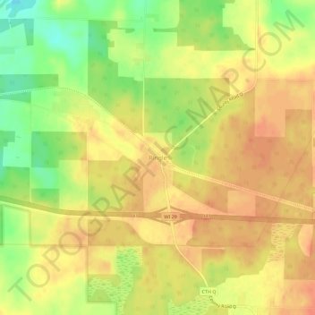
Name: Ringle topographic map, elevation, terrain.

Location: Ringle, Marathon County, Wisconsin, 54471, United States (44.87108 -89.44567 44.91108 -89.40567)

Average elevation: 1,316 ft

Minimum elevation: 1,220 ft

Maximum elevation: 1,365 ft

Marathon County trails, hiking, mountain biking, running and outdoor activities

Other topographic maps

Click on a map to view its topography, its elevation and its terrain.

Village of Weston

United States > Wisconsin > Marathon County

Average elevation: 1,217 ft

Rib Mountain

United States > Wisconsin > Marathon County

Average elevation: 1,247 ft

Rothschild

United States > Wisconsin > Marathon County

Average elevation: 1,204 ft

Abbotsford

United States > Wisconsin > Marathon County

Average elevation: 1,401 ft

Town of Wausau

United States > Wisconsin > Marathon County

Average elevation: 1,348 ft

Kronenwetter

United States > Wisconsin > Marathon County

Average elevation: 1,224 ft

Athens

United States > Wisconsin > Marathon County

Average elevation: 1,378 ft

Hatley

United States > Wisconsin > Marathon County

Average elevation: 1,289 ft

Town of Stettin

United States > Wisconsin > Marathon County

Average elevation: 1,306 ft

Spencer

United States > Wisconsin > Marathon County

Average elevation: 1,306 ft

Town of Berlin

United States > Wisconsin > Marathon County

Average elevation: 1,381 ft

Town of Brighton

United States > Wisconsin > Marathon County

Average elevation: 1,322 ft

Gear up for your next adventure:

📚USA Hiking Guide Books - Top trail guides and map books
🌐World Map Poster - Decorative world maps with topographic info
🕶️GPS Smartphone Mount - Secure mount for phone navigation
Camping Coffee Makers - Enjoy premium coffee at the summit or campsite
🥤Water Filter Bottle - All‑in‑one filter bottle for safe hydration

As an Amazon Associate, this site earns from qualifying purchases at no extra cost to you.