
Merrillan topographic map
Click on the map to display elevation.
About this map
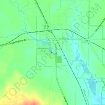
Name: Merrillan topographic map, elevation, terrain.
Location: Merrillan, Jackson County, Wisconsin, United States (44.43315 -90.84783 44.46221 -90.82114)
Average elevation: 935 ft
Minimum elevation: 879 ft
Maximum elevation: 1,040 ft
Jackson County trails, hiking, mountain biking, running and outdoor activities
Other topographic maps
Click on a map to view its topography, its elevation and its terrain.
Black River Falls
United States > Wisconsin > Jackson County > Black River Falls
Average elevation: 866 ft
York
United States > Wisconsin > Jackson County > Town of Northfield
York is in Jackson County, at latitude 44.5 and longitude −91.145 and at an elevation of 896 feet. It appears on the Pigeon Falls U.S Geological Survey Map and is in the Central Time Zone.
Average elevation: 971 ft