
Malad topographic map
Interactive map
Click on the map to display elevation.
About this map
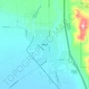
Name: Malad topographic map, elevation, terrain.
Location: Malad, Malad City, Oneida County, Idaho, United States (42.15159 -112.29080 42.23159 -112.21080)
Average elevation: 4,813 ft
Minimum elevation: 4,423 ft
Maximum elevation: 6,860 ft
According to the United States Census Bureau, the city has a total area of 1.66 square miles (4.30 km2), all of it land. It lies on the eastern edge of Malad Valley at 4,540 feet (1384 m) in elevation.
Other topographic maps
Click on a map to view its topography, its elevation and its terrain.
Cedarhill
United States > Idaho > Oneida County
Cedarhill, Oneida County, Idaho, United States
Average elevation: 5,417 ft
Malad City
United States > Idaho > Oneida County
Malad City, Oneida County, Idaho, United States
Average elevation: 4,613 ft