Geolocate

Ancona topographic map

Click on the map to display elevation.

About this map

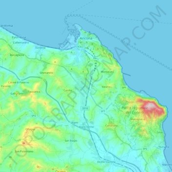
Name: Ancona topographic map, elevation, terrain.

Location: Ancona, Marche, Italy (43.50855 13.37618 43.63146 13.60906)

Average elevation: 236 ft

Minimum elevation: -16 ft

Maximum elevation: 1,857 ft

Other topographic maps

Click on a map to view its topography, its elevation and its terrain.

Gabriella

Italy > Marche > Ancona > Senigallia

Average elevation: 138 ft

Gear up for your next adventure:

🧥Waterproof Jacket for Hiking - Breathable and rugged rain jacket for outdoor excursions
🧼Biodegradable Camping Soap - Eco‑friendly soap for outdoor hygiene
🪶Paracord Bracelet - Survival bracelet with built‑in tools
🧺Microfiber Travel Towels - Compact and fast-drying towels for trail use
🪶Wildlife Field Guides - Learn animal tracking and species ID

As an Amazon Associate, this site earns from qualifying purchases at no extra cost to you.