Geolocate

Tuyo topographic map

Click on the map to display elevation.

About this map

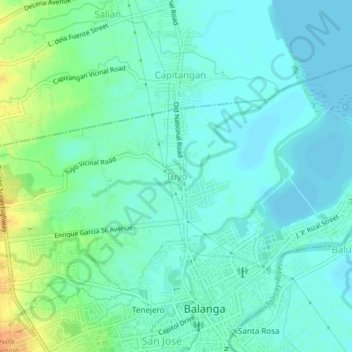
Name: Tuyo topographic map, elevation, terrain.

Location: Tuyo, Balanga, Bataan, Central Luzon, 2100, Philippines (14.67461 120.51768 14.71461 120.55768)

Average elevation: 33 ft

Minimum elevation: 0 ft

Maximum elevation: 115 ft

Other topographic maps

Click on a map to view its topography, its elevation and its terrain.

Cataning

Philippines > Bataan > Balanga

Average elevation: 36 ft

Gear up for your next adventure:

🧭Outdoor Navigation Book - Learn advanced navigation skills
🔌Solar Panel Charger - Charge gear sustainably outdoors
🏔️Mountain Trail Maps - High‑detail maps for popular peaks
Backpacking Tent - Lightweight and durable tent for multi‑day hikes
🧣Hiking Neck Gaiter - Multi‑use neck protection for outdoor weather

As an Amazon Associate, this site earns from qualifying purchases at no extra cost to you.