Geolocate

Cataning topographic map

Click on the map to display elevation.

About this map

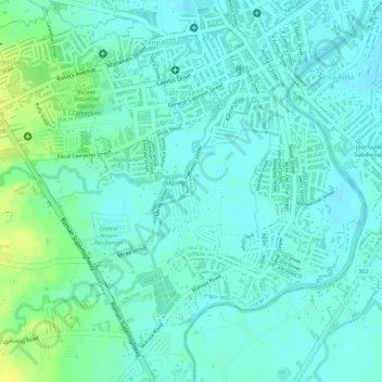
Name: Cataning topographic map, elevation, terrain.

Location: Cataning, Balanga, Bataan, Central Luzon, 2100, Philippines (14.66192 120.52781 14.67594 120.54138)

Average elevation: 36 ft

Minimum elevation: 13 ft

Maximum elevation: 85 ft

Other topographic maps

Click on a map to view its topography, its elevation and its terrain.

Balanga

Philippines > Bataan > Balanga

Average elevation: 440 ft

Tuyo

Philippines > Bataan > Balanga

Average elevation: 33 ft

Gear up for your next adventure:

❄️Traction Cleats - Prevent slips on icy trails during winter hikes
🪶Wildlife Field Guides - Learn animal tracking and species ID
👓Polarized Sunglasses - Outdoor sunglasses for glare reduction
📌Outdoor GPS Map App - Apps and devices for digital topographic navigation
🏔️Mountain Trail Maps - High‑detail maps for popular peaks

As an Amazon Associate, this site earns from qualifying purchases at no extra cost to you.