Geolocate

Mequon topographic map

Click on the map to display elevation.

About this map

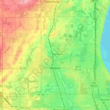
Name: Mequon topographic map, elevation, terrain.

Location: Mequon, Ozaukee County, Wisconsin, United States (43.19211 -88.06383 43.28037 -87.89368)

Average elevation: 732 ft

Minimum elevation: 561 ft

Maximum elevation: 984 ft

Ozaukee County trails, hiking, mountain biking, running and outdoor activities

Other topographic maps

Click on a map to view its topography, its elevation and its terrain.

Donges Bay

United States > Wisconsin > Ozaukee County

Average elevation: 623 ft

Gear up for your next adventure:

🗺️NatGeo Topo Maps - High-quality waterproof printed topographic maps of US Parks
🪶Multi‑Purpose Knife - Useful blade for camp and trail
🧯Portable Fire Pit - Compact fire pit for camping spots
👓Polarized Sunglasses - Outdoor sunglasses for glare reduction
🛌Ultralight Sleeping Bags - Compact down bags for cold nights in the wilderness

As an Amazon Associate, this site earns from qualifying purchases at no extra cost to you.