
Make a donation
Gear up for your next adventure:
As an Amazon Associate, this site earns from qualifying purchases at no extra cost to you.
Donges Bay topographic map
Click on the map to display elevation.
Make a donation
Gear up for your next adventure:
As an Amazon Associate, this site earns from qualifying purchases at no extra cost to you.
About this map
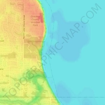
Name: Donges Bay topographic map, elevation, terrain.
Location: Donges Bay, Ozaukee County, Wisconsin, 53092, United States (43.20357 -87.89430 43.20367 -87.89420)
Average elevation: 623 ft
Minimum elevation: 561 ft
Maximum elevation: 738 ft
Ozaukee County trails, hiking, mountain biking, running and outdoor activities
Make a donation
Gear up for your next adventure:
As an Amazon Associate, this site earns from qualifying purchases at no extra cost to you.
Other topographic maps
Click on a map to view its topography, its elevation and its terrain.
Port Washington
United States > Wisconsin > Ozaukee County
The city is located on the western shore of Lake Michigan. In northern and southern parts of the city, the coastline is characterized by clay bluffs ranging from 80 feet (24 meters) to 130 feet (40 meters) in height with deep ravines where streams flow into the lake. Clay bluffs are a geological formation…
Average elevation: 673 ft
Make a donation
Gear up for your next adventure:
As an Amazon Associate, this site earns from qualifying purchases at no extra cost to you.
Port Washington
United States > Wisconsin > Ozaukee County
The city is located on the western shore of Lake Michigan. In northern and southern parts of the city, the coastline is characterized by clay bluffs ranging from 80 feet (24 meters) to 130 feet (40 meters) in height with deep ravines where streams flow into the lake. Clay bluffs are a geological formation…
Average elevation: 659 ft
Make a donation
Gear up for your next adventure:
As an Amazon Associate, this site earns from qualifying purchases at no extra cost to you.
Make a donation
Gear up for your next adventure:
As an Amazon Associate, this site earns from qualifying purchases at no extra cost to you.