
Wingerworth topographic map
Click on the map to display elevation.
About this map
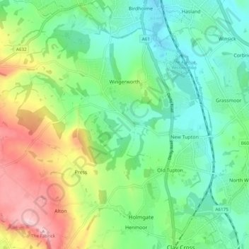
Name: Wingerworth topographic map, elevation, terrain.
Average elevation: 489 ft
Minimum elevation: 249 ft
Maximum elevation: 981 ft
Other topographic maps
Click on a map to view its topography, its elevation and its terrain.
Lightwood
United Kingdom > England > Derbyshire > North East Derbyshire > Eckington
Average elevation: 551 ft
Sutton Scarsdale
United Kingdom > England > Derbyshire > North East Derbyshire
Average elevation: 358 ft
Ogston Reservoir
United Kingdom > England > Derbyshire > North East Derbyshire > Woolley Moor
Average elevation: 449 ft
Doghole Wood
United Kingdom > England > Derbyshire > North East Derbyshire > Holymoorside
Average elevation: 466 ft
Middle Handley
United Kingdom > England > Derbyshire > North East Derbyshire
Average elevation: 449 ft
Dronfield Nature Park
United Kingdom > England > Derbyshire > North East Derbyshire > Dronfield > Unstone Green
Average elevation: 512 ft
Holestone Moor
United Kingdom > England > Derbyshire > North East Derbyshire > Ashover CP
Average elevation: 758 ft
Norwood Cottage Lakes
United Kingdom > England > Derbyshire > North East Derbyshire > Killamarsh
Average elevation: 305 ft
Highlane
United Kingdom > England > Derbyshire > North East Derbyshire > Eckington > Ridgeway
Average elevation: 427 ft
Grassmoor Country Park
United Kingdom > England > Derbyshire > North East Derbyshire > Corbriggs
Average elevation: 381 ft
Millthorpe
United Kingdom > England > Derbyshire > North East Derbyshire > Holmesfield > Millthorpe
Average elevation: 692 ft
Troway
United Kingdom > England > Derbyshire > North East Derbyshire > Eckington > Troway
Average elevation: 515 ft
Cartledge
United Kingdom > England > Derbyshire > North East Derbyshire > Holmesfield > Cartledge
Average elevation: 630 ft